The Daigu landform is represented by the Daigu in Linyi City. The summit was as flat and open as a plain, and the cliffs around the summit were like cutlasses. Below the cliffs is a geomorphic landscape of gradual gentle slopes. In Geomorphology, it belongs to table shaped mountains or square mountains in the geomorphic form, so it is also called "Fangshan landform".
The signature feature of the Daigu landscape is the steepness of the surrounding area of the summit, which is clearly faulted with the mountain body. The mountain top is relatively closed, and influenced by the area of the "islands", the vegetation development in the peripheral area of the mountain group is better than that in the core area, and the vegetation development on the mountain top is better than that on the mountain slope.
The origin of "Gu" is mainly that the Paleozoic Cambrian limestone underwent intense crustal cutting and uplift movement. After multiple dynamical actions, such as erosion, dissolution, gravitational collapse, and weathering, the crustal cut and uplift movement region developed a rounded appearance, with flat mountain tops, cliff-like surrounding cliffs, and steep slopes below the cliffs that gradually changed from steep to gentle, mostly in the shapes of camels, hats, tables, and cockscomb.
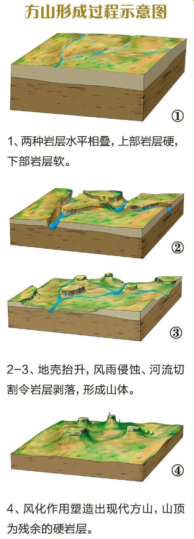
Over hundreds of millions of years of geological formations, Mengyin County and even the entire Yimeng Mountain area have undergone different ages of submarine sedimentation, forming the unique landscape of Daigu, where the upper layers are carbonate rocks and the lower layers are shale. As a result of the intense plate movement, the Yimeng Mountain region rose above the sea surface and subsequently underwent various geological processes such as surface water erosion, river cutting, weathering and erosion, and gravitational collapse. The lower part of the shale is soft and vulnerable to wind erosion, with severe water and soil loss. The thick carbonate rock of the upper portion was hardened, so that the flat top of the rock could be partially preserved, and thus formed Table Mountain or Square Mountain, the present-day form of Big Dipper.


